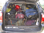
Loaded up for the three-day trip...
The weather forecast called for improving conditions. Good thing, since it poured the morning of our departure (June 29), then all night long while we were camped at Glacier Basin. Fortunately, it slowed to a drizzle or nothing at all during our walk into Glacier Basin, where we could see some of the havoc from last fall's storms. Hard to believe that relatively small creeks and rivers could do this kind of damage, but pretty cool from my nerd perspective.
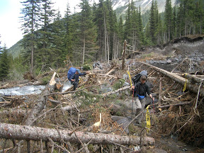
Dave and Dorothy on the "trail" to Glacier Basin (thanks volunteers for the flagging!)
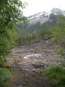
Drop off into oblivion.... Erosion from the November floods chewed up plenty of riverbanks and trail and created a steep scar on the opposite bank.
Saturday dawned sunny and warm, a welcome change. We had met up with Howard Weaver and Marlin at Glacier Basin, after their soggy attempt on Curtis Cliffs was thwarted. It was good to meet Howard in person after seeing his name for years through the Mountaineers. He knew Jo, so I let him know that we were on a special mission. We challenged Marlin to a moonwalk in his 8000-m boots (he was prepping for a trip to the Himalaya) and he made a brief attempt.
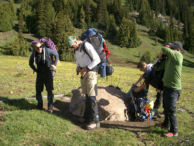
A sunny Saturday start from Glacier Basin, where the avalanche lilies were in bloom. Steve, Ben, Andrew, and David were making their first climb of Rainier.
The Interglacier was in stellar shape, with just one crevasse open up high on climber's left. The snow was just warm enough to make a solid step. We pulled on our harnesses near Camp Curtis to drop down to the Emmons and traverse over to Sherman. The drop was mostly snow covered, with very little ice showing (unlike 2006 at this time when ice made it challenging), but there were a few crevasses showing near the rocks so we swung wide.
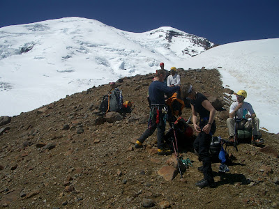
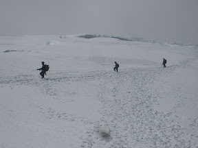
Gearing up near Camp Curtis, at the top of the Interglacier, before dropping down to the Emmons for the last climb to Camp Shurman.
Fortunately for us, there were only a handful of tents in Camp Sherman, and one low-key climbing ranger. We set up the Megamid on the snow, but David, Andrew, Ben, and Steve opted for the windier rocks for camp. Dave left his water filter stashed at Glacier Basin, so we spent the rest of the afternoon melting snow and bumming the filter from our teammates. The sun was roasting us, but it was better than rain.
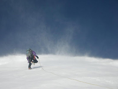
On Sunday, July 1, we got up at 12:30 a.m. and left camp around 2:10 a.m. Dave took his usual superhuman pace with Dorothy and Andrew, but I opted for the slow, steady plod with David and the last rope team with Dale, Steve, and Ben. The wind had been calm all night with a few surprising gusts that sounded like they accelerated from Glacier Basin. During our climb, these managed to pull a 180-degree turn and buffet us with a headwind of maybe 30-40 mph above about 10,500 ft. The entire way to the crest. As if slogging up a glacier and desperately seeking oxygen weren't hard enough.

Mindy somewhere on the Emmons Glacier
We could see the route from Camp Sherman pretty clearly, but it included a hard left turn around 12,500 ft and a zig so long that we couldn't see the zag to the summit. The climbing ranger told us that the route should go right at the zig, not left, and that left-going parties were having very long summit days or not summiting at all because of the extra half mile. Dave got the chance to set a new route through the crevasses and snow bridges, which was fun except that we didn't bring wands with us. With the wind, our footprints eroded before the next climber on the rope got there, so we kept looking backwards to memorize the descent route. We crossed a few snow bridges, one kind of manky one where I had David keep me on a carabiner-ice axe belay. A few climbers punched through to the kneecaps on the ascent and descent.
Jo's ashes were heavy and I wasn't feeling great, so when Dave offered to carry them at 13,500 ft I didn't even pause. Originally the plan was to share the weight among several climbers, but as Plans A through E from 2005 through June 2007 didn't work out and only Dave knew what I was up to, I had carried the ashes the whole way. That was 8 pounds in addition to my regular climbing gear and a tent I hauled into Glacier Basin when my original tent partner had to cancel.
As I pulled Jo's ashes from my pack high on Rainier's flank, my poofy down jacket jumped from my pack and started heading for Sherman. We watched it tumble downhill in the strong wind, jump a crevasse, then mysteriously come to rest around 12,000 ft. I was bummed but warm so far, so rather than worry I just mentally picked out what color my new one would be for my birthday this year.
We made Columbia Crest around 9:00 a.m., and the wind grew even stronger. As one rope team headed for the true summit, I completed my mission quietly on the side. I carefully opened the bags then held them up to the wind. This was no placid, calm scattering of ashes in a gentle breeze. Instead, Jo's ashes leaped from the bag in a stunning crescendo of action. In less than 10 seconds, her ashes had left Mt. Rainier and Washington State far behind.
When I asked Jim and Sarah Backus if they had anything they would like read or completed at the summit, they said no. Really, there just weren't any words left to send Jo on her final journey, and I just watched the ashes disperse. I've never been one to share grief with anyone, and I was relieved not to have to explain what I was doing.
The view was exceptional. Both times I had summited Rainier previously, clouds socked in the summit and I couldn't see a blasted thing. This time I could gaze down on Puget Sound over the crater of Rainier, something I had wanted to do for years. But thanks to my lost parka, I couldn't linger. In fact, I didn't even take my camera out of my pocket for a summit people or landscape picture. The views are why I climb to summits. This one is only in my head, though.
The team was pretty tired, including me, so we began the descent right away. Camp Sherman sure seems like a long way away from the top of Rainier, but we were down in about three hours. And I actually took some pictures on the descent, photos I couldn't have taken in the dark morning ascent even if I had thought about it.
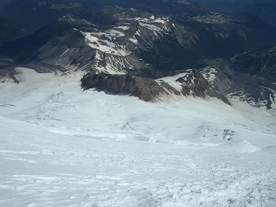
Camp Sherman and the top of the Interglacier from around 12,500 ft on the Emmons Glacier.
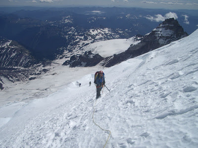
David with Little Tahoma and the other rope team in the distance.

Dave, Dorothy, and Andrew descending through warming, squishy snow just above Camp Sherman.
David and I were around 13,000 ft when I looked down and could still see the black dot of my parka, to the left of the descent route, about 1000 ft below us. As we got closer, even with the strong wind, the parka remained anchored to the slope. And, as we got even closer, I figured it was only three rope lengths off the descent route with a reasonable, low objective hazard path toward it. After checking with David, we headed off toward my parka. I just had to find out what was holding it to the snow.
David and I were around 13,000 ft when I looked down and could still see the black dot of my parka, to the left of the descent route, about 1000 ft below us. As we got closer, even with the strong wind, the parka remained anchored to the slope. And, as we got even closer, I figured it was only three rope lengths off the descent route with a reasonable, low objective hazard path toward it. After checking with David, we headed off toward my parka. I just had to find out what was holding it to the snow.
It was on a 15-degree downslope, maybe 20 ft above a crevasse. I snuck up on it, since it had jumped before, and grabbed it by the neck. What was holding it to the slope? Nothing. Nothing at all. One sleeve had a snowball in it and a small section of the neck was frozen into the snow, but there was no protrusion or anything for the jacket to catch on. Nothing. In a strong wind. Whether you believe in God, karma, or physics, something weird happened. I shook it out and stuffed it deep inside my pack. I still like the color (slate blue) so I think I'll keep it. Now I call it my karma jacket.
We retreated to Sherman, slogging through slushy snow that stuck to my aluminum crampons below 11,000 ft or so. I dashed my crampons as soon as I hit that stuff, since all I have to do is think about balling up and they do. We took a short break at camp, then packed up and headed back down the Interglacier, the site of the Best Glissade Ever. Well, one of the best. Gratifying to descend in minutes what took maybe a few hours on ascent.
The walk back was uneventful but long, especially since my big toe was repeatedly bashing into my Intuition liners. Guess FF didn't do such a great job on the fit, because I'll be losing my toenail to that trip.
I called Jim Backus as soon as we got into cell phone range, and let him know that we were finally successful. He quickly dashed off an e-mail to family and friends, letting them know that Rainier was Jo's final climb. It was a melancholy call and e-mail, and the end of a long journey. But I and the other 15 climbers involved with Plans A through F were honored to have completed this for Jim and his family, as well as for us.
I found it fitting that we released Jo's ashes on a Tacoma Mountaineers basic climb, when four basic students reached the summit as well. Jo was an exceptionally giving climber and volunteer. The climbers involved with previous attempts and plans were with us in spirit on Columbia Crest:
Marty Babare
Curt Baxstrom
Eric Black
Dave Buckland
Steve Carlin
Mark Hallman
Dale Hegg
Steve Kleine
Julie Myer
Karen Perz
Cindy Santamaria
Dennis Sherwood
Tom Shimko
Steve Townsend
Marty Babare
Curt Baxstrom
Eric Black
Dave Buckland
Steve Carlin
Mark Hallman
Dale Hegg
Steve Kleine
Julie Myer
Karen Perz
Cindy Santamaria
Dennis Sherwood
Tom Shimko
Steve Townsend


